Porcelain

Imhof

Azure
Coffee Can

GIS 331 - An analysis of zero-emission vehicle registration count in Canada. The count data from Statistics Canada was aggregated to the census subdivision boundary layer and symbolized for a visual analysis of where more zero-emission vehicles are being purchased.

GIS 314 - Analysis of ‘cyclist’ crime in Victoria BC. This analysis and map were completed entirely with QGIS as a practice in using open source GIS software. The map was an attempt to display correlation between bike path density and cyclist crime rates in the city. A brief visual analysis tells us that the neighborhoods with the highest rates of cyclist crime tend to fall along or near a bike path.

GIS 331 Term Project - In the varied landscapes of British Columbia, this detailed analysis of hepatitis C spread found links between the effects of particular socio-economic factors on virus rates. This poster outlines the findings of this in-depth study into the cumulative normalized case rates of hepatitis C from 2011 to 2019, with a spotlight on how variables like income (Low income after tax by household), education (population with any post-secondary education), and age bracket (normalized rates of people aged 15 to 24) influence these rates. It incorporates a logarithmic transformation to smooth the data distribution, providing a clearer understanding of hepatitis C spread across varied populations. The results illuminate the inverse correlations between hepatitis C rates and populations possessing higher education or populations within the younger age range of 15-24; furthermore, it also explains a positive correlation with lower income brackets. This study navigates the statistical questions within this data, confirming the model's strength with key variables that enhance its explanatory power, ensuring no bias or redundancy. It passes all six statistical benchmarks, establishing a model that not only captures nearly half of the variance in hepatitis C rates but also portrays a spatial narrative of the virus. This analysis provides us with actionable data and allows us to integrate socio-economic factors into public health decision making to combat the spread of hepatitis C in the province.

GIS 307 Term Project - One of the individual watershed maps from the Hawkins road slope analysis.

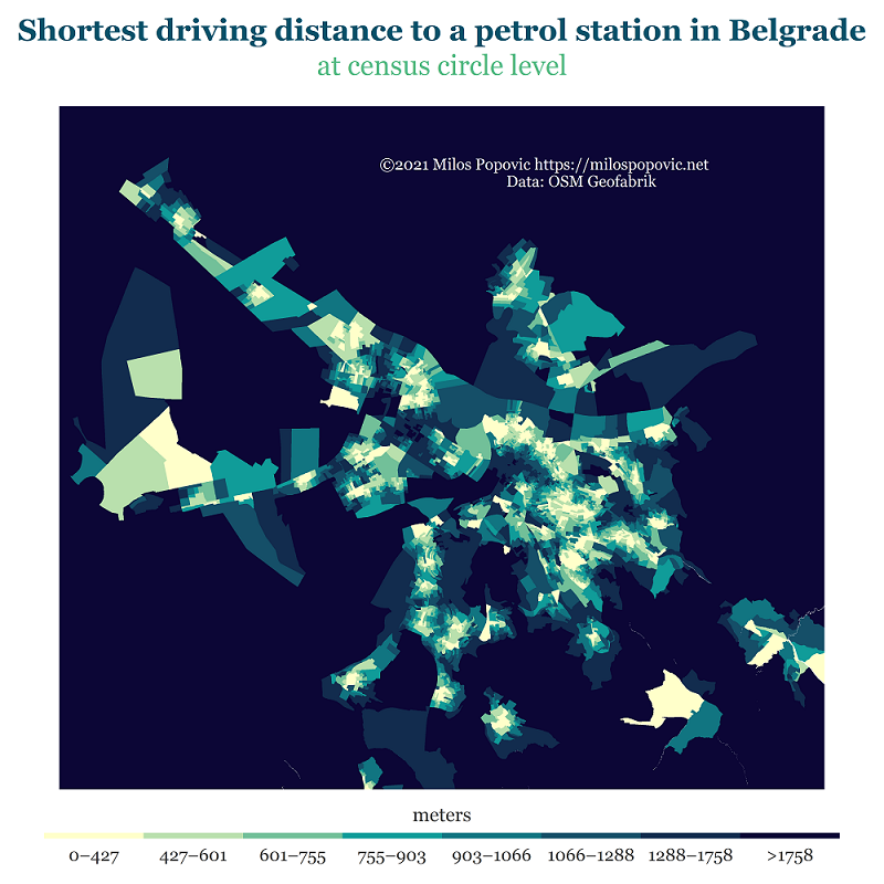
GIS 325 - In this assignment we were asked to choose any website and trace and map the intermediary bounces of the webpage request. The trace was completed using the Windows Command Prompt to acquire the route to your chosen site, then using ‘IP Address Lookup - Free IP Checker Tool | NordVPN’ to look up the physical location of those hops. I then created a table out of that data and used ‘XY to point’ in ArcGIS Pro to create the feature class. Finally, I created the ‘trace’ line to connect the dots using the ‘Points to Line’ tool.

GIS 307 Term Project - In this geospatial analysis conducted for British Columbia Timber Sales (BCTS), LiDAR-derived elevation models were used to assess road slopes within the Hawkins Operating Area located in the East Kootenay region of British Columbia. The study aims to help make future management strategies more informed, especially in areas critical to wildlife species such as the grizzly bear and the Rocky Mountain tailed frog. Findings indicated an average road slope of 25.10% and a density of 1.28 km/km² for the entire study area; however, the variations between individual watersheds highlights the need for targeted management and conservation objectives within particular habitats. Rocky Mountain Tailed Frog habitat 75331 and the ‘Elmer Creek SB’ polygon areas are of highest concern. Despite the limitations posed by variations in data resolution, the outcomes of this analysis serve BCTS with actionable data. The process focused on extracting and analyzing road network characteristics within watersheds, including slope and density calculations, through manual segmentation and a custom script for geoprocessing. This script automated the analysis of road slopes and densities, utilizing a series of GIS tools to generate and categorize road features, facilitating a comprehensive assessment of watershed road networks.